Cyclone Biparjoy
A deep depression that formed in the Arabian Sea has developed into a cyclonic storm called Biparjoy. As of Wednesday at 2:30 am, the cyclone was located approximately 900 kilometers west-southwest of Goa, 1020 kilometers southwest of Mumbai, 1090 kilometers south-southwest of Porbandar, and 1380 kilometers south of Karachi.
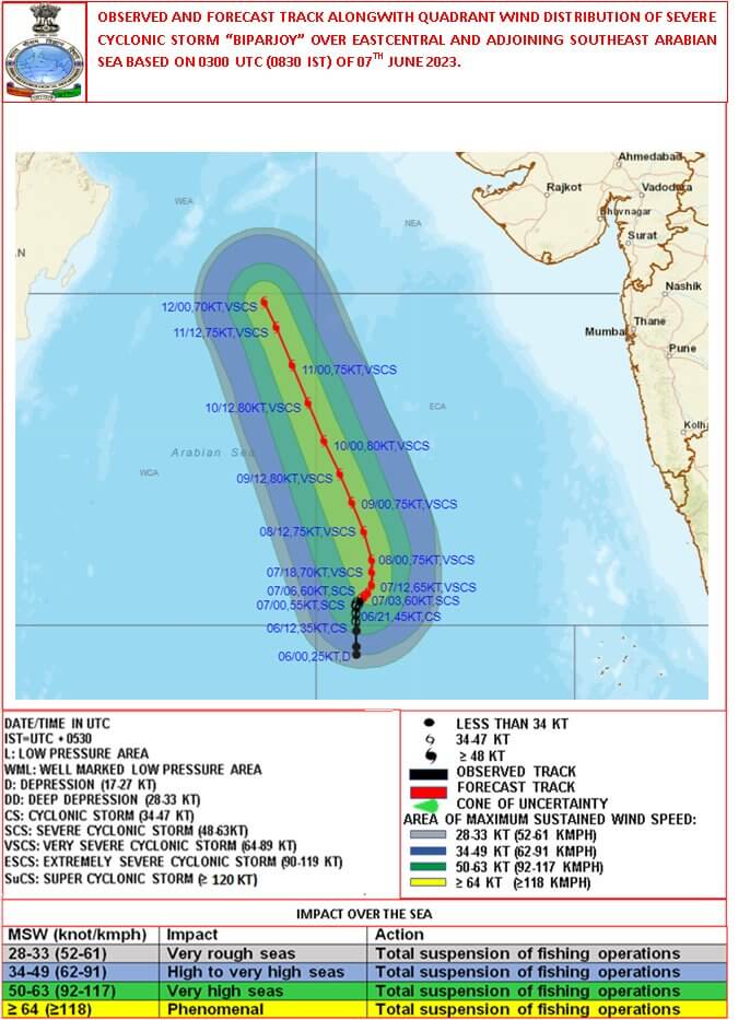
Cyclone Biparjoy is significant because it is the first cyclone to form in the Arabian Sea this season. The India Meteorological Department (IMD) has forecasted that the cyclone is expected to move in a northward direction and gradually intensify into a severe cyclonic storm over the east-central Arabian Sea by Wednesday morning. Furthermore, it is anticipated to further intensify into a very severe cyclonic storm within the following 24 hours in the same region, according to the IMD.
Trajectory of Cyclone Biparjoy
- The forecast for Cyclone Biparjoy indicates that it will track northwards along the west coast of India and is projected to make landfall in Gujarat on June 10.
- Following landfall, the cyclone is anticipated to weaken and continue its path into Pakistan.
- As the cyclone progresses, it is likely to bring strong winds that could potentially lead to power outages and property damage.
- It is crucial for individuals residing in the affected areas to take necessary precautions and prioritize their safety. Following the guidance and instructions of local authorities is highly recommended to ensure the well-being of everyone in the region.
Who named the Cyclone Biparjoy?
- The cyclone was named Biparjoy by Bangladesh.
- The name means “disaster” or “calamity” in Bengali.
- The World Meteorological Organization (WMO) rotates a list of names for tropical cyclones in the North Indian Ocean, and Bangladesh submitted the name Biparjoy for the 2023 season.
How the Cyclone Biparjoy will impact Monsoon in India?
The cyclonic storm, Biparjoy, is expected to have a significant impact on the arrival of the monsoon along the Kerala coast, which is already experiencing a delay. While private forecasting firm Skymet Weather suggests a possible arrival on June 8 or 9, it may be a gradual and subdued entry.
- The presence of powerful weather systems in the Arabian Sea, such as Cyclone Biparjoy, disrupts the inland progression of the monsoon. Although the monsoon flow may reach coastal areas, it will face challenges in penetrating beyond the Western Ghats.
- Roxy Mathew Koll, a senior climate expert from the Indian Institute of Tropical Meteorology (IITM), Pune, explained that Biparjoy, unlike previous cyclones Nisarg or Tauktae, is located further away from the Indian coast.
- Consequently, it is unlikely to have a direct impact on the west coast, except for occasional gusts of wind resulting from a combination of cyclonic and monsoon winds.
- However, as the cyclone forms over the Arabian Sea and moves north-northwestward, it could divert moisture away from India, potentially affecting the onset and progression of the monsoon.
The typical onset of the southwest monsoon in Kerala is around June 1, with a standard deviation of approximately seven days. The India Meteorological Department (IMD) previously predicted an arrival in the southern state by June 4. However, the actual date of the monsoon’s onset is still uncertain.
Affect on other States
The delay in the arrival of the monsoon in Kerala, caused by a low-pressure system in the Arabian Sea, does not necessarily indicate a delay in the monsoon reaching other parts of the country. Scientists explain that the delayed onset in Kerala does not affect the overall rainfall across India during the monsoon season.
- The IMD recently stated that despite the emergence of El Niño conditions, normal rainfall is expected throughout the country during the southwest monsoon season.
- The northwest region of India may experience normal to below-normal rainfall, while the east and northeast, central, and south peninsula regions are expected to receive rainfall ranging from 94% to 106% of the long-term average of 87 cm.
- The delayed monsoon arrival can also impact Mumbai, a city reliant on rainwater to replenish its reservoirs. The presence of a cyclone usually affects the onset of the monsoon, causing a delay of approximately one to two days. As the cyclone moves away from the coast, its impact on Mumbai will become more evident.
- When a cyclone is situated along the southern and western coastal lines, it can have a favorable effect on the start of the monsoon. This was observed when Cyclone Nisarg made landfall in Maharashtra in 2020, positively influencing the monsoon’s onset.
- However, Cyclone Biparjoy, positioned in the Arabian Sea far from the Indian coast, is considered more of a hindrance. It interferes with the monsoon’s onset, weakening the monsoon current and causing delays in favorable conditions for its arrival. As a result, Biparjoy is contributing to the delay in the monsoon’s onset.
Cyclone Biparjoy and El Nino
- According to experts, Cyclone Biparjoy and the evolving El Niño phenomenon are both contributing to the challenges faced by this year’s monsoon.
- In the past, El Niño was known to affect the intensity and rainfall patterns of the monsoon, particularly in August. However, the situation has changed this year.
- The impact of El Niño has started and is progressing.
- For El Niño to have a significant effect, the ocean and atmosphere need to be synchronized. Initially, the ocean was warming, creating favorable conditions for El Niño, but the atmosphere was not in alignment.
- Now, the atmosphere has also started to align, leading to the faster-than-expected development of El Niño’s impact.
- This accelerated evolution of El Niño is likely to have an impact on the monsoon across the entire nation.
Also Read about the very severe cyclonic storm, named Cyclone Mocha, formed in the North Indian Ocean region on May 11th.
- 3 August Current Affairs 2023 in English
- MoU Between Subroto Mukerjee Sports and Education Society and All India Football Federation (AIFF) to Promote Football at Grassroot Level
- Dr. Mansukh Mandaviya Delivers Keynote Address at the 13th Indian Organ Donation Day ceremony
- Education Ministry Forms Expert Panel on Anti-Discrimination in Higher Education
- Concerns Arise Over Cheetah Deaths at Kuno National Park
Cyclone Biparjoy – FAQs
What is the speed of the Cyclone Biparjoy?
What is the normal onset and retreat date of monsoon in India?
Onset: June 1 to 10 over Kerala, June 10 to 20 over Mumbai, and June 20 to 30 over Delhi.
Retreat: September 1 to 10 over Kerala, September 10 to 20 over Mumbai, and September 20 to 30 over Delhi.
However, the monsoon can sometimes be delayed or early. For example, in 2022, the monsoon set in over Kerala on May 29, which was the earliest onset in 14 years.